


- Search
- Riyadh35 ° C


Zubaida Trail, a historic landmark and ancient international road to Makkah
Saudi Arabia is rich with a large number of historic trails the inhabitants of the Arabian Peninsula traveled along before and after Islam.
However, Zubaida Trail remains one of its most famous trails because of its monuments that are still found today. This has earned its registration in the UNESCO World Heritage List, among 10 sites the Saudi Commission for Tourism and National Heritage (SCTH) asked to register, based on the Royal approval on Oct. 10, 2014.
Zubaida Trail, or Al-Kufi pilgrimage route, runs from Kufa in Iraq to Makkah, passing through the north of the Kingdom and its center.
It stretches more than 1,400 km in the Kingdom and passes through the following five areas: Northern Borders Region, Ha’il, Al-Qassim, Madinah and Makkah.
The trail was listed among the projects of the Two Holy Mosques program to care for the Kingdom’s cultural heritage, executed by the SCTH among its initiatives in the National Transformation Program.
Zubaida Trail was named after Zubaydah bin Jafar, wife of the Abbasid Caliph Harun Al-Rashid for her charitable work, in addition to the number of stations she ordered to be established along the trail.
Zubaida Trail was a trade route in the pre-Islamic era, but its importance increased with the dawn of Islam and it flourished during the time of the early caliphate. According to the report by the SCTH, the trail reached its peak during the Abbasid Caliphate between the years 750 and 1258, when the road and pavements were installed.
Stations were also installed, wells, pools and dams were established and houses were built. Twenty-seven major stations have been identified, most importantly Al-Sheihiyat, Al-Jumaima, Faid, Al-Rabadha, That-Erq and Khuraba.
The trail has an outstanding universal value; it embodies the cultural importance of exchanges and multidimensional dialogues between countries. It gathered many Muslim pilgrims from different races and regions, and religious, cultural and scientific exchanges started between people from around the world.
The trail also highlights interactions in terms of locations and times from the pre-Islamic era until the end of the Abbasid Caliphate era in the 13th century.
Many historians, geographers and travelers have written about Zubaida Trail. Some of the most notable ones are: Ibn Khordadbeh, ibn Rustah, Al-Yaqoobi, Al-Maqdisi, Al-Hamdani, Ibn Jubayr and Ibn Battuta. The trail also attracted a number of Western travelers who walked along it and wrote about it during the 19th and 20th century.
According to historical sources, this trail aimed to “serve pilgrims from Baghdad” which was the capital of Abbasid Caliphate to Makkah, enrich cultures and commercial exchange at the time with a length spanning 1,400 km. Markers were placed along the road to guide pilgrims. Pools were also installed to smartly gather water in carefully chosen locations along the distances to provide pilgrims with water.
The trail runs through a number of mountains, highlands and depressions and was mentioned in the books of geographers, ancient travelers from Muslims and other religions. It was mentioned by Finnish Georg Wallin and Anne Blunt in Blunt’s book “A Pilgrimage to Nejd” and while some monuments of this trail have disappeared, some ruins are still found today.
Archaeologist and Professor Saad Al-Rashid said the Zubaida Trail was planned in a practical way and was elaborately engineered. Its directions were specified stations and houses were installed along it and the road was paved with stones in sandy and muddy areas, cleared of boulders and obstacles in inaccessible areas and mountains. The road was also engineered with a delicate system to distribute waterworks from dams, wells, pools, springs and canals, and flags, lighthouses, “stones distance markers,” torches and fireplaces were placed in a careful manner to guide travelers day and night.
Geographers and Muslim pilgrims observed the number of stations and houses on the trail between Kufa and Makkah and counted 27 main stations and 27 houses or “secondary stations” which are considered rest stops built at a specific distance between two main stations, not taking into consideration the other houses and facilities that were installed along the route.
Geographers also tracked the stations and houses on roads that fork from the main road of the trail. One of the Basra road branches meets with the Kufa road, where it bifurcates to Makkah south and Madinah west. The pilgrimage route also meets the Zubaida Trail near Makkah.
Historian Ibn Kathir said: “The Hejaz road stretched from the safest road in Iraq,” but the road, along with other roads from the main and secondary ones, was subjected to tribal attacks in consecutive periods, owing to security problems. The pilgrims and travelers were unable to cross the main road or any of its branches without military care and protection from the caliphate’s capital.
The road was disrupted to a great extent after the Siege of Baghdad at the hands of Mongol forces in 1258 and the road was intermittently used after that. Most stations along the trail gradually disappeared and the stations and houses were diminished to ruins. Some wells and pools remained usable but the majority were covered with sand over time.
Studies and archaeological surveys have revealed patterns of castles, fortifications, houses, accommodations and mosques in a number of archaeological sites which were main stations on the route.
These locations consisted of cities and villages serving the inhabitants of those areas, the convoys of pilgrims, merchants and travelers and provided them with food, water, clothes and livestock feed. Many of them were markets thriving with agricultural and animal products and various industries.
Some of the most famous archaeological sites which represented cities and big main stations were Zabala, Al-Thaalabiya, Fayd, Al-Sumaira, Al-Naqra, Al-Rabatha and Maa’den bin Slim.
Archaeological research in historic Fayd have revealed an advanced network of wells, springs, canals and pools, and their diverse architectural aspects focused mainly on building fortified castles, houses, facilities, mosques and roads to a big city. Diverse patterns of archaeological findings have been also revealed pottery, ceramic and glass utensils, metal, and stone tools and coins.
These findings are consistent with the information of the historical and geographical sources and the writings of Muslim pilgrims about this city which was one of the most ancient Islamic cities in the heart of the Arabian Peninsula, a main station in the middle of Zubaida Trail between Kufa and Makkah.
In historical Al-Rabadha site, comprehensive archaeological excavations have taken place for more than 20 years. Excavations in the location revealed a mosque, a residential area, houses and castles’ units, markets, manufacturing sites, warehouses, pools and tanks of groundwater.
The archaeological findings in Al-Rabadha are an important source for researchers since it is one of the early Islamic cities. Al-Rabadha was a city and a main station in the location that determined one-third of the road from Kufa. Some of these findings include pottery, ceramic, glass and metal utensils, jewelry and decorative items, coins and carvings. Life in Al-Rabadha lasted from the beginning of Islam until 917 when it was ruined and left by its inhabitants.
Archaeological studies have shown that the architectural structures on the pilgrimage route from Kufa to Makkah represent an architectural pattern that is exceptional to early Islamic architecture in the Arabian Peninsula that is represented in the architectural plans and different functions.
The buildings also stand out because of the thickness of the walls and protective towers. The houses and accommodations’ building blocks in Al-Rabadha were equipped with tanks to preserve drinking water under the rooms, squares and passageways’ floors, and a number of stations included the markets and public bathrooms, among other facilities.
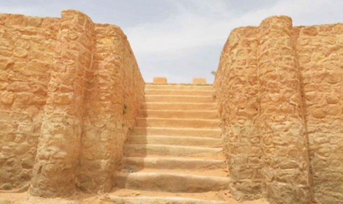
About charting the Zubaida Trail and its ramifications, engineers specified its directions in most parts. It crosses flat rangelands, rugged terrain and desolate deserts until it reaches the Hijaz Mountains’ difficult terrain penetrated by narrow and deep valleys. The road was facilitated by passageways between mountain paths, and the trail was protected with high walls on both sides. Wide terraces were placed in rugged mountainous regions and experienced engineers excelled at charting the way while avoiding routes with torrential rain.
Dr. Hussain Abu Al-Hassan of SCTH clarified that the commission conducted a full survey of archaeological Zubaida Trail, restored some of the monuments and rehabilitated them as part of the project “Old Trade and Hajj Routes in the Kingdom.”


 loan from Bank of China to finance an Uzbekistan solar project")


